|
|
Local History
Geomorphic History The origin of Tasmania's North East can be traced to the rifting events associated with the break-up of Tasmania and Antarctica from the supercontinent of Gondwana. While Tasmania stayed structurally attached to the Australian continent, the depression created by the rift is now occupied by Bass Strait. The volcanic activity during this rift is still evident with volcanic plugs at Stanley, Table Cape and Mt.Cameron, as well as the rich red volcanic soils stretching from Ulverstone to Scottsdale. This red soil shows where Tasmania first broke free. The area north of this volcanic soil, from the Tamar rift to Cape Portland, is largely sandy ground. This is the result of accumulated sand which has travelled eastwards through Bass Strait over the last 6,500 years, and has become colonised by vegetation as the sand became established as the new coastline. | 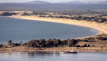
A member of Bridport's fishing fleet makes its way to work,with the Barnbougle Dunes as a backdrop. (Photo courtesy of Jeff Jennings)
| | The dunes along Barnbougle and the Waterhouse coastal reserve form one of the world's largest dune fields stretching along 25km of beach, over 10000acres in area and featuring dunes over 150feet high. Some areas of these dunes continue to drift inland, while others, including the dunes at Barnbougle have been stabilised with the introduction of Marram grass from Britain around World War II. It is this marram grass, so predominant in the coastlines of the British Isles that gives Barnbougle its special Irish feel. | Tasmanian AboriginalsThe first human inhabitants of the area were the Aboriginals who occupied Tasmania when it was still attached to mainland Australia. The Trawlwoolway and Pyemmairrenerpairrener bands of the North-East tribe inhabited the area around Bridport when Europeans first came to the area. They lived mainly on the coast, dining on shellfish, coastal mammals and the wide array of birdlife which flocked to the coastal waterways. The hinterland was largely impenetrable scrub. However during the warmer months they spent more time inland, making their way up the river valleys and long established tracks following their animal food sources. The native Tasmanian tiger and emu (now extinct) were prolific in the area. Some of the last Tasmanian Aborigines to be brought in for re-settling to the Furneaux Group of islands were located in the area by George Augustus Robinson in 1831. | European SettlementThe first European settlers in the area were the Anderson's who settled what is now Barnbougle as early as 1829. Martin Mowbray Stephenson purchased the property in 1845 and re-named it after Barnbougle Castle, which was his ancestral Scottish home. Barnbougle Castle is on the Firth of Forth west of Edinburgh. Interestingly, an unrealised but extremely elaborate redesign of Barnbougle Castle in 1774 by prominent early British architect Robert Adam recently featured at the National Gallery of Scotland in Edinburgh. | 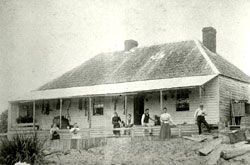
The original Barnbougle farm homestead with Mowbray Stephenson family (mid 1800's) | 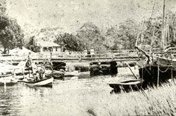
'Coronella' mooored at the mouth of the Brid river (late 1880's) | For much of the 1800's Tasmania's north-east was most commonly accessed by sea, with a busy sea-trade between Launceston and the Bass Strait Islands making Bridport a point of call. Barnbougle itself was home to an illicit whisky still, which was popular with the sailors, sealers and whalers who used the nearby Waterhouse Island as a safe harbour. The town of Bridport was first surveyed and settled in the early 1860's, but was not proclaimed as a township until 1883. Like many other nearby towns, Bridport is named after a coastal village in Dorset, England. Between that time the area boomed as gold and tin mining in the region took off, and Bridport was selected as the most suitable port. However, by 1910 the area had stagnated as the mining speculation declined and a railway from Launceston to nearby Scottsdale saw Bridport's role as a port decline. | | But during and after World War One Bridport once again prospered as the railway was extended from Scottsdale to Bridport, a major timber mill started operation and 2 large jetties were erected to assist in the loading and unloading of vessels. After the war a new soldier settlers scheme saw many returned serviceman granted land in the Bridport district. By 1920 Bridport was being described as 'the Riviera of the North' and the burgeoning summer population was entertained with fishing, boating, picnicing and swimming. The advent of the Motor car and the associated increases in mobility and travel hastened Bridport's emergence as a haven for those seeking sunshine, sea-air and beaches. | 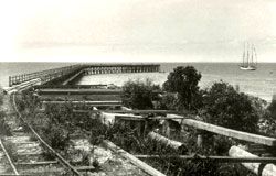
The Croquet Lawn Beach Jetty with sailing brig 'Rahra' about to moor. | Third Time Lucky?In 1929 a large golf resort was first proposed for Bridport at Granite Point, featuring a 200 room hotel, restaurants, a country club and 18-hole championship golf course designed by Scottish golf architect G.B Oliver. The development was in the style of Scotland's Gleneagles but had the cliff-top coastal location similar to America's Pebble Beach (interestingly, the developer was the Grand-Father of Australian cricketer and commentator Max Walker). However the imminent depression put an end to these plans, and Bridport was to remain a sleepy seaside town, reliant on farming and fishing and a popular destination for Launceston holiday makers. | 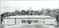
The architectural sketch of the proposed 220 room hotel from the 1929 Prospectus. | | In 1991 Japanese businessman Yutaka Tanaka purchased the large property 'Bridwood' 10minutes west of Bridport for development of a $1billion large-scale resort featuring four golf courses, 5star hotel and residential development, spread over 5000acres. These plans were scuttled by the global recession of the early 1990's and the farm sold. It is expected that for Bridport's sake, it is third time lucky for this golf development. We also hope that unlike the other two proposals, this is not a forerunner for a global economic downturn! While both these earlier sites proposed were on good sandy coastal ground, the dunes at Barnbougle make it a far superior site for golf, and the location east of the bay and minimalist design will ensure the development will not in any way detract from Bridport's sleepy, seaside charm. The area has a bright future, with a dynamic local government and business community pursuing a range of initiatives with tourism and lifestyle services high on the agenda. |
|